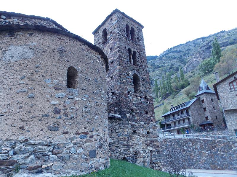
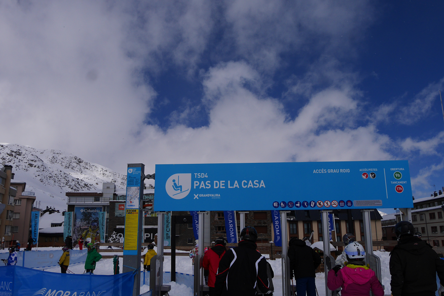
Friday, January 31, 2020

Ordino

ordino
Ordino
Ordino (cat. Ordino) – is the capital of the eponymous parish of Andorra. Ordino is the northern parish in the Principality of Andorra. The parish is located in an area of 89,3 sq. km. Ordino is located 6 km from the capital Andorra La Vella.
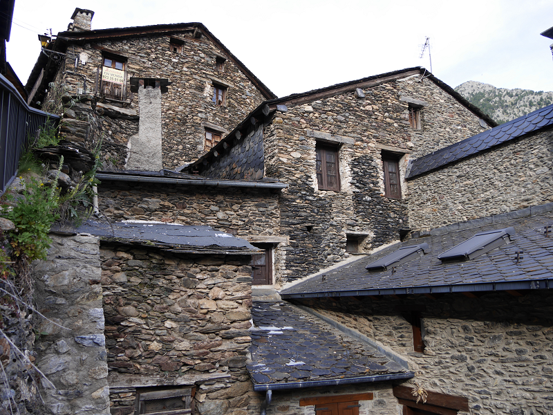
Ordino parish consists of 5 villages: La Cortinada, Ansalonga, Llorts, Sornas and Ordino.
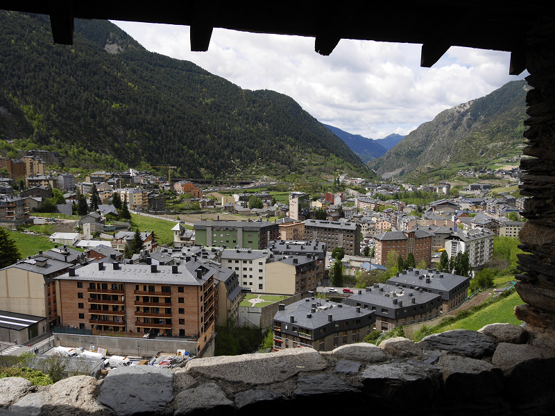
Ordino is the third, according to the traditional order, of the seven parishes in Andorra. With 90 km² it is the largest one after Canillo. The parish includes the basin of the river Valira d’Ordino or Valira del Nord, located to the northwest of the Principality. It borders to the north with the Country of Foix (Auzat and Vic de Sòs), to the east with Canillo and to the south and west with La Massana.
Historically Ordino had stood out for its forges, especially Farga del Serrat and that of Areny. The closure of the forges and emigration in the late 19th century led to a sharp decline of inhabitants (454 in 1932 and 402 in 1970). In the seventies, coinciding with the expansion of tourism and the consequent construction of new houses, which have led to urbanizations in Cegudet, Ansalonga, Cortinada and El Serrat, there has been a notable recovery of the population, with a census of 713 inhabitants in 1980 and 778 in 1983.

Canillo

canillo
Canillo
Canillo (cat. Canillo) — the capital of the eponymous parish of Andorra. The parish is located in the northeastern part of the country, it is the largest by area in Andorra. The distance to the capital Andorra La Vella is 10 km. The parish of Canillo consist of 14 villages (Soldeu, Bordes d’Envalira, El Tarter, Sant Pere, Ransol, Els Plans, El Vilar, l’Armiana, l’Aldosa, El Forn, Incles, Prats, Meritxell and Molleres).
The proximity to the largest ski resort of Andorra Grandvalira has determined the pace of development of the County from a tourist point of view. Today Canillo has all the advanced and ultra-modern ski facilities for tourists. The lifts leading to the main stations of Grandvalira, located in Canillo, Soldeu and Tarter (Canillo district).
The biggest Ice Palace in the Pyrenees is located in Canillo. The complex offers a wide range of opportunities for leisure and sporting events—for individuals and for groups with corresponding package of services.

Sant Julia de Loria

Sant Julia de Loria
Sant Julia de Loria (cat. Sant Julià de Lória) — is the capital of the eponymous parish of Andorra. It is located on the South of the country at a distance of 5 km from the capital Andorra La Vella, 2 km from the border of Andorra with Spain.
Sant Julià de Lòria is the sixth parish, according to the protocol order of the seven parishes of Andorra. It is formed by the town of Sant Julià de Lòria and five quarts or parochial subdivisions: Quart de Bixessarri (Bixessarri and Aixovall), Quart d’Aixirivall (Aixirivall), Quart d’Aubinyà (Aubinyà and Juverri), Quart de Fontaneda (Fontaneda, Les Pardines, Mas d’Alins and La Muxella) and Quart de Nagol (Nagol, Certers and Llumeneres).
When a visitor enters Andorra through the Spanish border, Sant Julià is his first contact with the principality; Its main tourist attractions are the large shopping centres, however, it also has magnificent landscapes to discover and an extraordinary set of churches and small chapels, the most important one of which is the Sanctuary of Our Lady of Canonical (in Catalan: Santuari de La nostra Senyora de Canòlic).

Andorra la Vella

highest capital andorra la vella
Highest capital city in Europe. Capital of Andorra – Andorra la Vella
In accordance with Article 2.3 of the Constitution Andorra la Vella is the capital of the Principality of Andorra and forms one of the seven parishes to which the country is divided.  The settlement of Andorra la Vella has been the principal city of Andorra since 1278 when the French and the Episcopal co-princes concluded an agreement on joint suzerainty.
With an area of 12 km² and a population of 22,886 inhabitants in 2018, it is the smallest parish and the most populated at the same time. It is located at the confluence of the Valira del Norte and Valira d’Orient rivers, where Valira forms, and it is at an altitude of 1,022 m. It forms an urban agglomeration of some 40,000 inhabitants together with the population of Escaldes-Engordany.

Os de Civís

Os de Civís – an interesting tourist spot near Andorra
Os de Civís is a village in the central Pyrenees mountains, in the municipality of Les Valls de Valira in Catalonia, Spain, and is located to the west of Andorra, near the villages of Aixàs and Bixessarri.
This is a village you can reach from Andorra without passing the official border. There is no border control between Andorra and Spain at this road at all. It takes about 10 minutes to reach the city from Sant Julia de Loria (by CG6).
The city is situated on the territory of the Spanish National Park L’Alt Pirineu. 5 hikind routes of different complexity through the park are available from this city.

Collioure

Collioure (in Catalan: Cotlliure) is a town, head of the commune of the same name, of about 3000 inhabitants, of the region of Roussillon, in the Northern Catalonia.
Nowadays, along with the towns of Argelès-sur-MerPort-Vendres, Banyuls de la Marenda, Cervera de la Marenda, Palau del Vidre and Sant Andreu de Sureda, it is part of the canton number 5 of the Vermillion Coast (new grouping of municipalities resulting from the cantonal restructuring carried out on the occasion of the cantonal and departmental elections of 2019), with a capital in Argelers.
Former fishing and wine-growing village, known for its anchovies, Collioure has also been an inspiration for painters such as Matisse, Derain, Chagall, Gris, Braque, Picasso, Dufy and Dalí, among others, who portrayed its castle, its alleyways or the picturesque bell tower of its church by the sea.
On the cemetery of Collioure there are the tombs of Antonio Machado and the novelist Patrick O’Brian, who lived there between 1949 and 2000.
The nickname of the people of Collioure is ganxeros or conyics. The saying goes: “It is good to live in Collioure, and in Argelers, if you have money.”

La Seu D’Urgell

La Seu D’Urgell. The Catalan heart of the Pyrenees
La Seu d’Urgell (formerly Urgell or Ciutat d’Urgell) is a town located in the Catalan Pyrenees, capital of the county of Alt Urgell, in the province of Lleida, head of the judicial district of the Seu d’Urgell, headquarters of the diocese of Urgell and was the head of the old county of Urgell. It is within the functional area of Alt Pirineu i Aran district, of which it is the most populated town, concentrating 17.4% of the districts inhabitants. Together with Puigcerdà, it has up to thirty percent of the population in the area.
It is located at the confluence of the Segre and Valira rivers, shortly before its conflux on a small river terrace that is the continuation of the Forques plains. The city is part of the Urgellet, a Pyrenean natural region formed by 16 municipalities of the Alt Urgell that along with Andorra corresponded to the original territory of the County of Urgell (Comtat d’Urgell) with capital in the Seu d’Urgell until the expansion to the south.

Sort

Cities of Catalonia: “Good luck city” as mark of the best European rafting city Sort (Lleida Province)
Sort is the capital of the provinces Pallars Sobirà, Lleida, Catalonia, Spain. The city is located at an altitude of 692 m above sea level, near the Noguera Pallaresa River, a tributary of the Segre River.
Population: 2.113 (in 2005). Population density: 20.4 / km²
Area: 105.13 km²
The name “Sort” in Catalan means “good luck”. The lottery ticket shop “La Bruixa d’Or” (“Golden Witch”) is the most famous in Catalonia. They say that this shop sells a lot of winning tickets – according to statistics, those who buy tickets from this shop are more likely to win.

Encamp

Encamp
The city of Encamp (Encamp) is located 7 km North from the capital Andorra La Vella.
The city of Encamp is the capital of the eponymous district of Andorra. Encamp district includes the village of Les Bons, Vila, El Tremat, La Mosquera and ski station of Pas de La Casa. The city is located in the valley of Сortals.
The city began to develop rapidly due to the construction of the cable car (Funicamp) which later connected the city with the ski stations Grau Rouge and Pas de La Casa. The length of the ropeway is 6 km away. Encamp today – is the best place for skiing due to its proximity to the capital’s infrastructure of Andorra la Vella and major ski stations of the largest ski resort of Andorra Grandvalira.

Font-Romeu

Font-Romeu: the land of the champions
The city of Font-Romeu is located in the Languedoc-Roussillon region of the Eastern Pyrenees (Pyrénées-Orientales) on the Cerdagne plateau, 40 km from Andorra, 87 km from Perpignan (France) and 170 km from Barcelona (Spain, Catalonia). The city is “the heart of the Catalan Pyrenees” with panoramic views, clean air, and bright light. It is located at an altitude of 1800 m above sea level.
The city has about 6,500 inhabitants, with about 2,050 of those being permanent residents.
History of Font-Romeu
At the beginning of the 20th century, on the site of the city of Font-Romeu, there was only a patch of wasteland. In 1903, Jacques Calvet, the mayor of Perpignan and Odeillo from 1902 to 1912, built several chalets in the forest of La Calme in order to spend the weekend there with friends. Consequently, a residence, which became known as Les chalets d’Odeillo, appeared, however, the beginnings of a city was still far away.

Pas de la Casa

Pas de la Casa (cat. El Pas de la Casa) is a village in the Principality of Andorra located in the parish of Encamp. In 2014 it had 2,434 inhabitants. The village is located on the border between Andorra and France, at 2,050 meters above sea level.
It must be said that at the beginning of the 20th century there was only a shepherd’s hut in this place of passage, which had been known formerly as Pas del Bac or Bac de la Casa.
Geography
Situated between 2000 and 2200 m a. s. l., it is the fourth highest town in Europe, only surpassed by Juf in Switzerland, Trepalle in Italy and St. Veran in France.

Valls

Valls (cat. Valls) is the capital of the Alt Camp region. It is located 19 km from Tarragona at 215 m above sea level. It includes the decentralised municipal entity of Picamoixons.
History
The city of Valls is nestled in a passage area. This means that since prehistory the area has been occupied by man. The findings of the Picamoixons site are good examples, among others. Later, at the time of the Iberians and in the later Romanisation, the areas of Valls were inhabited intensely. The Vilar Iberian site and the Ibero-Roman bakery Fontscaldes represent this.
But the proper birth of the city did not occur until the first half of the 12th century, once the Saracens, from Siurana and the Prades mountain range, were defeated.

L’Estartit

L’Estartit is a coastal town that belongs administratively to the municipality of Torroella de Montgrí, incorporated to a decentralized municipal entity. In 2009 it had a population of 3,571 inhabitants registered. Located south of the last hills of the Montgrí massif, it is a town that is inextricably linked to the Mediterranean Sea. It is just over a kilometre from the archipelago of the Medes Islands, recognized for its large quantity of submarine species of flora and fauna.
L’Estartit is geographically dominated by the Empordà plains and the last stretch of the Ter river: the Gola and Ter Petit wetlands which are due in a large part to the fine sand that forms the beaches of the Pals Bay. The fortified farms located between Torroella and L’Estartit (Torre Martina, Torre Gran, Mas Ral, Torre Quintaneta…) also stand out in this setting, many of them are visible from the road to GI-645. Equally dominant over the landscape is the sudden elevation of the Montgrí massif with the two nearby and distinguishable peaks of the Moratxa and Rocamaura Turrets. It is on top of this plateau that the abandoned LORAN base is located.

Hostalric

Hostalric is a town and municipality of the Selva comarca (Girona, Catalonia). It is part of the subregion of Baix Montseny. In 2018 it had a population of 4139.
Hostalric was, in the past, an obligatory passage area on the North-South route and the only natural path between Girona and Barcelona. In some surveys, done on the castle hill, remains from the Iberian period were found. In Roman times an internal division of the Via Augusta passed through this place. The remains of this route were found when the road to Sant Hilari Sacalm was built. The town of Hostalric seems to have originated with a hostel, documented from the 11th century on the site of Onota, at the foot of the so-called Camino de Francia (ancient Roman road). The toponym Hostalric is a joining of ‘hostal’ and ‘ric’ (cat. rich). The first clear documentary record of Hostalric is from 1106 and in it Guerau Ponç, viscount of Cabrera, swore fidelity to Ramon Berenguer III of Barcelona.

Port-Vendres

The town of Port-Vendres (fr. Port-Vendres, cat. Portvendres) is located in the extreme northwest of the district, near the town of Collioure. Port-Vendres is one of the few deep-water ports in this part of the French Mediterranean coast. It takes freighters and cruise ships, as well as large and small fishing boats which may be seen arriving with their daily catch.
Port-Vendres has existed since the Iron Age, when it was used as a port connected to the Iberian settlement of Illiberis (now Elna). In the first century of our era, the Roman geographer Pomponi Mela mentions Portus Veneris (the Port of Venus). It is certainly related to the Aphrodisium, or temple of the Venus de Pirene, mentioned by Estrabó, Plini and Ptolemeu, probably a temple of Venus aimed to bring luck to the sailors. This temple, according to archaeological surveys of the 19th century, could have been in the northeast of the town, in the area delimited by Miranda, Fanal and Ansa Gerbal. It has not yet been fully verified, but structures of 10 to 4 meters excavated on the shale rock on the site could have been the base of the temple. It was at the foot of the Fanal and about 5 meters above sea level. Its northeastern corner was rebuilt with remains of Roman tegulae/

Port Leucate

Port Leucate – the cheapest oysters in France and the center of European land windsurfing (Amethyst Coast)
Leucate (fr. Leucate) – a commune in France, which belongs to the region Languedoc-Roussillon. Department of the Commune – Aude. Included in the canton Les Corbières Méditerranée. District of the commune – the city of Narbonne. The population of Leucate in 2017 was 3,954 people.
This seaside resort is located on the coastal strip separating Leucate pond from the golfe du Lion Bay, in the immediate vicinity of the marine Corbières (les Corbières maritimes), which are located in the east and differ from the rest of the Corbières by having a mild climate and plenty of thermal Mediterranean vegetation.

Ciboure

Ciboure is a French municipality, located in the Atlantic Pyrenees Department (Pyrénées-Atlantiques), in the New Aquitaine region (Nouvelle-Aquitaine). Ciboure (Ziburu in Basque) means «end of the bridge».
One part of the town is part of the Basque province of Labourd, the other is part of the French region of Bayonne.
Ciboure is divided from the town of Saint-Jean-de-Luz by the Nivelle river and the port in the Bay of Biscay. As a neighbor of the “royal city”, who greeted Louis XIV during his marriage with Maria Theresa, Infanta of Spain (Marie-Thérèse d’Autriche), in 1643, Ciboure also offers an equally outstanding heritage in the form of Socoa Fort, which guarded the exit to the Bay of Biscay.
Ciboure is one of the most popular Atlantic resorts in France today.
Tourism, sights, and what to see?
The main resort’s attraction is Socoa Fort, which was built under King Louis XIII (father of the “Sun King”), and then improved by Sebastien Vauban – a famous French engineer, Marshal of France, and writer (his fortresses are declared World Heritage of Humanity).

Saint-Jean-de-Luz

Saint-Jean-de-Luz is a former fishing village, a commune in the Atlantic Pyrenees department (Pyrénées-Atlantiques) in southwestern France. Saint-Jean-de-Luz is part of the Labourd (Lapurdi) Basque province.
Saint-Jean-de-Luz is known for its architecture, sandy bay, a large number of sunny days per year, and excellent cuisine. The town is located south of Biarritz, on the Nivelle river’s right bank.
It is a mistake to assume that the town name comes from “Luz”, which means “light” in Spanish. “Luz” is a mutation of “Lohitz” in this case, which means “dirty place, marsh”. And this name corresponds to those times when the settlement was flooded and was nothing more than a marsh for centuries.
The Gulf of Saint-Jean-de-Luz is a natural harbour in the Bay of Biscay southeast between Arcachon and Spain. It has become a favorite destination for tourists on the Basque coast due to its location and strong “walls” protecting the town from the Atlantic Ocean. The sea resort itself appears relatively new, however, the town port is several centuries old.

Orthez

Orthez is a town in the French department of the Atlantic Pyrenees (Pyrénées-Atlantiques), located on the Gave de Pau’s right bank.
“Touch if you dare” (French “Touches-y si tu l’oses”) is Orthez’s motto, which testifies to a rich and eventful history. Its cultural heritage and landscapes testify to a double essence – from the medieval fortifications rigidity to the tiled roofs softness and comfort.
The town of Orthez dates back to the Middle Ages. Orthez switched from Viscounts of Dax to Viscounts of Bearn at the end of the XII century, Viscount of Bearn, Gaston VII de Moncade made it his residence in 1242. He endowed the town with its main attractions: the Moncade Castle (Château Moncade) – a 10-minute walk from the town center – and the Pont-Vieux bridge.

Tarragona

Tarragona is a city located in the northeast of Spain (the region of Catalonia). Today it is one of the most important historical centers of Spain and an important seaport (Costa Daurada).
Tarragona contains many historical buildings dating back to the Ancient Roman period which are included on the list of UNESCO World Heritage sites. The city is associated with the era when Tarraco (the ancient name of Tarragona) was one of the most important cities on the Iberian peninsula. Tarragona shows the real history of mankind, connecting several thousand years of development. Here you can spot Ferraris in the streets alongside ancient ruins, a medieval Gothic cathedral, cobblestone streets and petrochemical complexes.

Salou

Salou – the most popular sea resort in Catalonia, Spain
Salou is a famous seaside resort and tourist center of the Catalonia region. It is located 10 kilometers from Tarragona on the “Gold Coast” (Costa Daurada) and about 90 kilometers from Barcelona. It is also close to the famous amusement park Port Aventura (originally the park was created and belonged to the American film company Universal Studios).
Tourism, sights and main attractions
Bonet house. On the main facade of the building there is a sundial, decorated with ceramic mosaics and an inscription made in the Gothic font, the meaning of which is: “Use the time, for it goes away irrevocably”.

Reus

Reus: the birthplace of Antonio Gaudi
Reus is a municipality in Catalonia, part of the province of Tarragona as part of the autonomous community of Catalonia. It is the second in the province of Tarragona after the city of Tarragona by population.
Sights, attractions or things to see in Reus
Reus attracts tourists primarily with the so-called pedestrian routes “in the Art Nouveau style”. The city has a huge number of architectural monuments of this era.
In addition, in Reus (in the homeland of the most famous Catalonian architect Antoni Gaudi), you can find the iconic Gaudi museum.
The Gaudi Center in Reus (Gaudi Center Reus). Among the locals, it is known as the “Gaudi Casket”. The museum is a three-story complex. It was opened in 2007 and is dedicated to the work of Antoni Gaudi, his life and work in Reus, as well as his role in world architecture. It should be noted that in Reus itself there is not a single object of architecture by Antoni Gaudi. In the museum you can see drawings, drawings, mock-ups, details of his buildings, descriptions, templates, manuscripts and notes.

Calafell

Calafell – the best seaside resort in Catalonia for holidays with children
Calafell is a municipality in the Spanish province of Tarragona, in the tourist region of Costa Daurada. In the east the city borders on Cunit, in the west – with Vendrell. An official document issued by the Government of Catalonia confirms Calafell’s specialization – family tourism.
This is the best place for a relaxing holiday: in a city with a population of only 25 thousand people it is quiet, safe, and comfortable. The sandy beaches of the resort are marked with the sign of the world standard of “blue flags”, confirming the quality and purity of the water and the beach as a whole. The city has numerous restaurants offering fresh fish dishes. The medieval and ancient monuments of architecture (the historical center of the town of Calafell) are only a 10-minute walk from the beaches.

Vic

Vic (cat. Vic) is the capital of the Osona region, in northeastern Catalonia. Its geographical location, 70 kilometers from Barcelona and 65 from Girona, has made it one of the capitals of the interior Catalonia. It has a population is of 48,287 inhabitants (2018).
The name of this town was written for centuries with the Vich form, according to traditional spelling. Since the beginning of the 80’s, the official form is “Vic”, in application of the Orthographic Norms of the Institute of Catalan Studies. The spelling with final “h” remains in the surname Vich, and also it is the one that has the homonymous town of Arpitania.
Tourism attractions, architecture and what to see?
It is a city worth visiting, because it has one of the most suggestive medieval ensembles in Catalonia, which was voted one of the seven wonders of Catalonia in 2007. The center of the old town is Plaça del Mercadal or Plaça Major, where several modernist buildings, arcades and towers stand out. The Episcopal Museum of Vic has one of the best collections of Medieval Catalan Art and is declared a museum of national interest by the Generalitat of Catalonia.

Sitges

Sitges and its sights
Sitges – a municipality in Spain, is part of the province of Barcelona as part of the autonomous community of Catalonia.
The municipality is located in the district Garraf.
History: Sitges belongs to one of the oldest settlements of the Iberian peninsula. The first mention of the settlement of the Iberian tribes dates back to the 4th century AD. Since the 12th century, power in the surrounding settlements was in the hands of the dynasty of Sitges, from which the city received its name. The economic potential of this Spanish region was mainly based on winemaking and wine trade with other cities in Spain and other European countries.
Over the past 20 years, the population of Sitges has almost doubled and acquired the features of “cosmopolitanism and multinationalism”: 35% of residents are citizens of Great Britain, the Netherlands, France and, most notably, the richest country in Europe (where the highest standard of living is registered) – Scandinavia.

Saint-Lizier

Saint-Lizier (fr. Saint Lizier), located above the Salat river at the foot of the Cuseran mountains (montagnes du Couserans), only 8 kilometers from Saint-Girons, is perhaps the richest historical heritage of the Department Ariege.
This area is also famous for its beautiful valleys and picturesque mountains.
History
Some historians believe that the city of Saint-Lizier was founded by Pompey in 72 BC. Others claim that the city was built as a Roman Oppidum (temporary fortress city of the Roman Empire period) in the third century BC. There is a third point of view, according to which the city was founded in 120 BC. and was inhabited by Couserans.
Anyway, Saint-Lizier throughout its history was an important religious center of the region.

Torroella de Montgrí

Torroella de Montgrí is a town and municipality that occupies the northeastern part of the Baix Empordà region. The town of Torroella is located on the Empordà plain, at the foot of the Montgrí massif on the north bank of the River Ter. It is part of the Montgrí, Medes Islands and Baix Ter Natural Park.
The main centre of the town is undoubtedly Torroella. It is nestled at the foot of Montgrí, it stretches in continuous urbanization that reaches the centre of Ullà, to the west, through the C-31 road. The other important centre, due to the number of inhabitants, is Estartit, about 5 km east of the town connected by the Gi-641 local road.
Apart from these main centres, in the municipality, some residential areas are also located on both sides of this road: Torre Moratxa, Dunes, Salats and Torre Gran. Also in the north of the district, there are the inner residential areas of Bolleria (near Bellcaire d’Empordà) and Sobrestany (one kilometre east of Bolleria), in the northeastern part of the municipality, there is Cala Montgó, closer to the l’Escala municipality than that of Torroella.